
CFD Simulation for Pedestrian Comfort in Urban Planning
Pedestrian comfort is a crucial measure of livability in modern cities. By integrating CFD simulation into the early stages of urban planning, designers can visualize invisible forces — wind and heat — and create data-driven solutions for outdoor comfort.
CASE-STUDIESARTICLES
Wiratama
11/1/20254 min read

CFD Simulation for Pedestrian Comfort in Urban Planning
As cities grow denser and taller, the comfort and safety of pedestrians in urban environments have become key aspects of sustainable design. Among the most powerful tools for assessing these factors is Computational Fluid Dynamics (CFD) simulation — a method that models how air flows through streets, around buildings, and across open spaces.
By applying CFD to pedestrian comfort analysis, urban planners, architects, and environmental engineers can predict and optimize the effects of wind, temperature, and thermal comfort, creating public spaces that are not only functional but pleasant to experience.
Understanding Pedestrian Comfort
Pedestrian comfort primarily relates to how people feel when exposed to wind and temperature conditions in outdoor environments. It can be divided into two main categories:
Wind Comfort: Ensures wind speeds in walkways, plazas, and entrances remain within tolerable limits for daily activities like walking, sitting, or cycling.
Thermal Comfort: Considers the combined effects of air temperature, radiation, humidity, and wind on human comfort, often evaluated using indices like Predicted Mean Vote (PMV) or Universal Thermal Climate Index (UTCI).
Excessive wind speeds can cause discomfort, hinder mobility, or even create safety risks. On the other hand, low wind speeds in hot climates can trap heat, making outdoor areas uncomfortably warm. Achieving balance is the key — and this is where CFD simulation excels.
How CFD Simulation Works in Urban Comfort Design
Computational Fluid Dynamics (CFD) uses numerical methods to simulate airflow and heat transfer. In the context of urban planning, it models how wind interacts with buildings, vegetation, and open spaces.
Here’s how CFD supports pedestrian comfort analysis:
Model Creation
The 3D geometry of the urban area — including buildings, streets, and vegetation — is imported from CAD or BIM models.Boundary Conditions Setup
Wind profiles based on local climate data (direction, speed, turbulence) are applied at the domain boundaries. Solar radiation and surface temperatures may also be defined for thermal analysis.Flow Simulation
CFD solves equations for airflow (Navier-Stokes equations), turbulence, and sometimes thermal radiation to predict velocity, temperature, and pressure distribution throughout the environment.Result Analysis
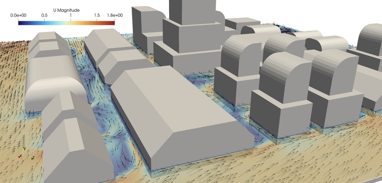
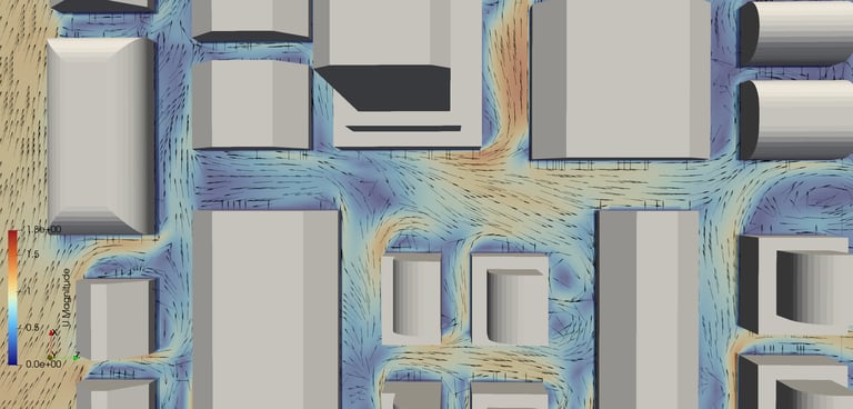
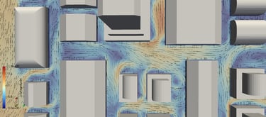
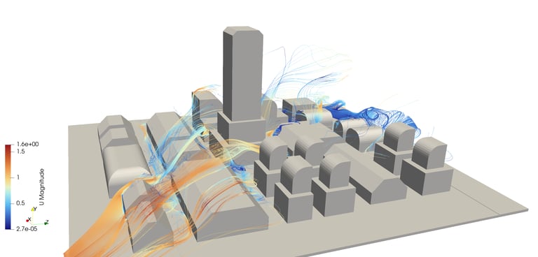
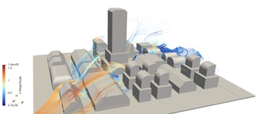
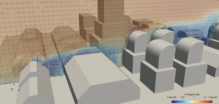
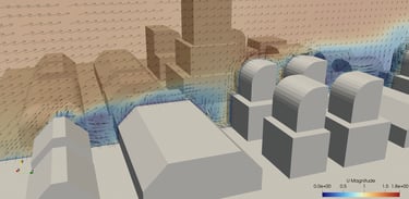
Post-processing tools visualize results as wind speed contours, streamlines, and comfort maps, showing how wind behaves around buildings and pedestrian zones.
Key Comfort Indicators from CFD
Wind Velocity Maps
CFD shows where wind accelerates between buildings (the “canyon effect”) or slows in sheltered areas. Designers can identify zones of discomfort and optimize layouts.Turbulence Intensity
Excessive turbulence near corners or high-rise podiums can cause unpredictable gusts. CFD visualizes these effects clearly for mitigation.Thermal Comfort Metrics (PMV, PPD, UTCI)
CFD can couple air velocity and temperature fields to compute comfort indices that reflect human perception in outdoor environments.Air Temperature Distribution
CFD thermal analysis predicts how urban heat accumulates in certain areas — critical for mitigating urban heat island (UHI) effects.Wind Safety Assessment
High-rise clusters can cause strong downdrafts. CFD identifies these regions to ensure compliance with wind safety standards like Lawson or NEN 8100.
Applications in Urban Design
Public Squares and Plazas: Ensure comfortable wind conditions for outdoor dining, events, and social interaction.
High-Rise Developments: Analyze wind downdrafts and acceleration zones to protect pedestrians at building bases.
Transit Stations and Entrances: Avoid strong gusts at exits, improving safety and accessibility.
Green Urban Corridors: Simulate how trees and landscaping influence airflow and temperature.
Smart City Planning: Combine CFD results with IoT data to monitor and optimize real-time comfort conditions.
CFD Simulation in Action: A Practical Example
Imagine a new mixed-use development surrounded by tall office towers. Early design studies show strong wind gusts at street corners.
Using CFD, planners simulate the airflow under various conditions:
Adding wind canopies at entrances
Modifying building setbacks and podium heights
Introducing trees or porous screens for wind diffusion
The resulting CFD maps show how these interventions reduce peak wind speeds and expand comfortable pedestrian zones. This process helps designers make informed choices — not based on guesswork, but on data.
How tensorHVAC-Pro Simplifies the Process
While traditional CFD tools can be complex, tensorHVAC-Pro makes flow and thermal simulation accessible for architects and urban planners. It’s a dedicated simulation platform designed for built-environment applications, capable of evaluating air velocity, temperature, and comfort across outdoor spaces.
With tensorHVAC-Pro, users can:
Import site geometry directly from CAD/BIM
Set local wind profiles and sun conditions
Generate pedestrian wind comfort maps automatically
Visualize thermal comfort zones under seasonal scenarios
Export results for reports or design presentations
The software provides a clear, visual understanding of how design choices affect pedestrian experience — without requiring deep CFD expertise.
Benefits of CFD for Pedestrian Comfort Design
Quantitative Validation
CFD provides measurable data on wind and temperature conditions, enabling compliance with comfort standards.Improved Design Decisions
Helps optimize building shapes, orientations, and landscaping for maximum comfort.Early Problem Detection
Identifies discomfort or hazard zones before construction.Sustainability Integration
Supports energy-efficient and climate-resilient city designs by improving natural ventilation.Enhanced Public Experience
Creates safer, more enjoyable outdoor environments that encourage social activity and walkability.
Conclusion
Pedestrian comfort is a crucial measure of livability in modern cities. By integrating CFD simulation into the early stages of urban planning, designers can visualize invisible forces — wind and heat — and create data-driven solutions for outdoor comfort.
With accessible tools like tensorHVAC-Pro, engineers and planners can bring scientific precision into every design decision, ensuring that public spaces are not only architecturally impressive but also comfortable, safe, and sustainable for the people who use them every day.
tensorHVAC-Pro is a dedicated HVAC flow and thermal simulation software, Intuitive and easy to use, designed for HVAC engineers - not CFD expert. Learn more..
Read more case studies..